From benchmark to forecast desk: AI tropical cyclone forecasting in Nature
WeatherNext Cyclones, in Nature: on average a day or more of extra lead time for cyclone track and intensity, and use at the US National Hurricane Center.
AI weather models · Probabilistic forecasting · Meteorology · Research notes
TL;DR
- WeatherNext Cyclones (WN-C), from Google DeepMind and Google Research with co-authors at the US National Hurricane Center (NHC), the UK Met Office and other institutions, is an AI ensemble model for the track, intensity and size of tropical cyclones worldwide.
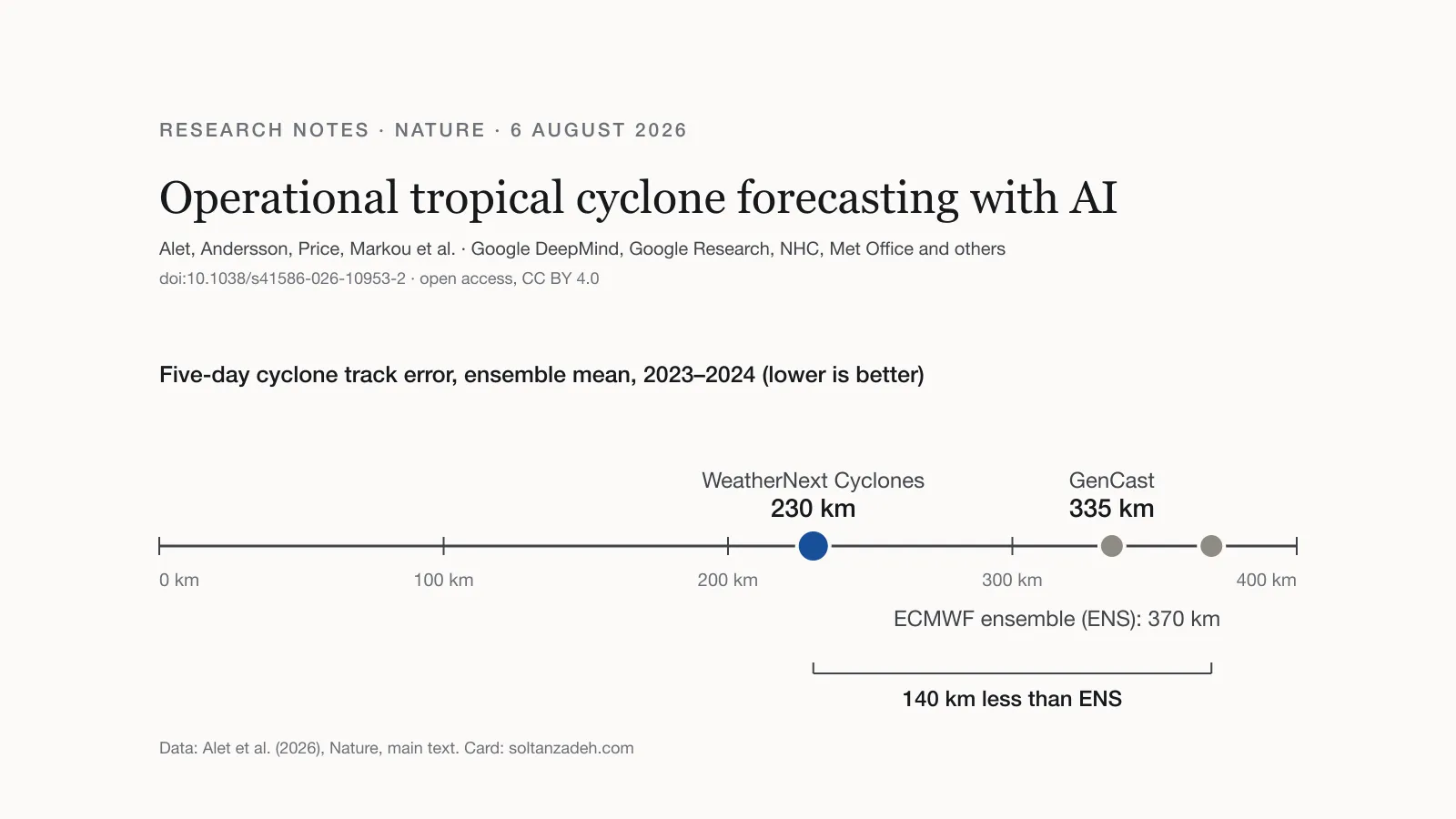
- On cyclones from 2023 to 2025 it gave on average a day or more of extra lead time over leading operational models. At five days, in the 2023–2024 test years, its ensemble-mean track error was 230 km against 370 km for ECMWF’s ensemble; in the Atlantic and East Pacific its intensity error was also lower than that of NOAA’s high-resolution HAFS model.
- Experimental forecasts went to the NHC during the 2025 Atlantic hurricane season, and forecasters there began using them in the official forecast process.
What was published
Nature published WN-C by Ferran Alet and colleagues online on 6 August 2026; the final version followed on 9 September. Several of the authors also wrote GenCast, which I summarised in December 2024, and GenCast is one of the baselines in the paper.
The paper starts from a long-standing dilemma. Global models such as ECMWF’s ensemble (ENS) usually forecast cyclone tracks best but lack the resolution for intensity. High-resolution regional models such as NOAA’s Hurricane Analysis and Forecast System (HAFS) capture intensity better, at the expense of track accuracy. Earlier AI weather models already gave state-of-the-art track forecasts but inherited the low intensity bias of their 0.25° training data.
How the model works
- Co-training. WN-C learns from about 20 TB of ECMWF analysis data and, at the same time, from IBTrACS, an expert-curated record of nearly 5,000 observed cyclones that amounts to only about 10 MB. It predicts the weather and, alongside it, each cyclone’s position, maximum wind, minimum pressure and wind radii.
- Probabilistic by design. It is trained on a probabilistic score (CRPS) and generates members with what the authors call functional generative networks, needing one network call per step. The authors report it about eight times faster at inference than GenCast.
- Ensembles of up to 1,000 members, each a complete 15-day global forecast in 6-hour steps at 0.25°.
The results
Design choices were frozen on 2022 data. Cyclone forecasts were tested on 2023–2024 worldwide and on the 2025 season in the North Atlantic and East Pacific.
- Track. Five-day ensemble-mean error of 230 km, against 335 km for GenCast and 370 km for ENS. ENS reaches a 230 km error after about 3.75 days, so WN-C gives just over 30 hours of extra warning at that accuracy (chart below).
- Intensity. In the North Atlantic and East Pacific, where HAFS runs, WN-C’s ensemble mean had a lower error than HAFS at all lead times, significantly so from 0.5 to 3.25 days. At three days it was 3.75 knots more accurate, which the authors compare with ten years of progress in numerical models. They read this as evidence that high resolution is not a strict prerequisite for intensity skill, since WN-C’s inputs are orders of magnitude coarser than those of regional models.
- Size. Errors in the 34-knot wind radius were significantly lower than those of both ENS and HAFS.
- Uncertainty. Probabilistic intensity errors (CRPS) were more than 50 % lower than those of ENS and of GenCast, whose intensities the authors bias-corrected to make it a stronger baseline, at many lead times.
- Rapid intensification. For rapid intensification within the first 24 hours, in the Atlantic and East Pacific, WN-C reached a critical success index of 0.5, against just under 0.3 for leading operational models. The authors note that no single model excels at this.
- Wind probabilities. 50-member forecasts of the probability of 64-knot winds gave significantly more relative economic value than ENS across all cost/loss ratios, lead times and wind thresholds; 1,000 members added substantial value, especially at low cost/loss ratios and long lead times.
- General weather. CRPS significantly better than ENS on 99.2 % of variables, levels and lead times.
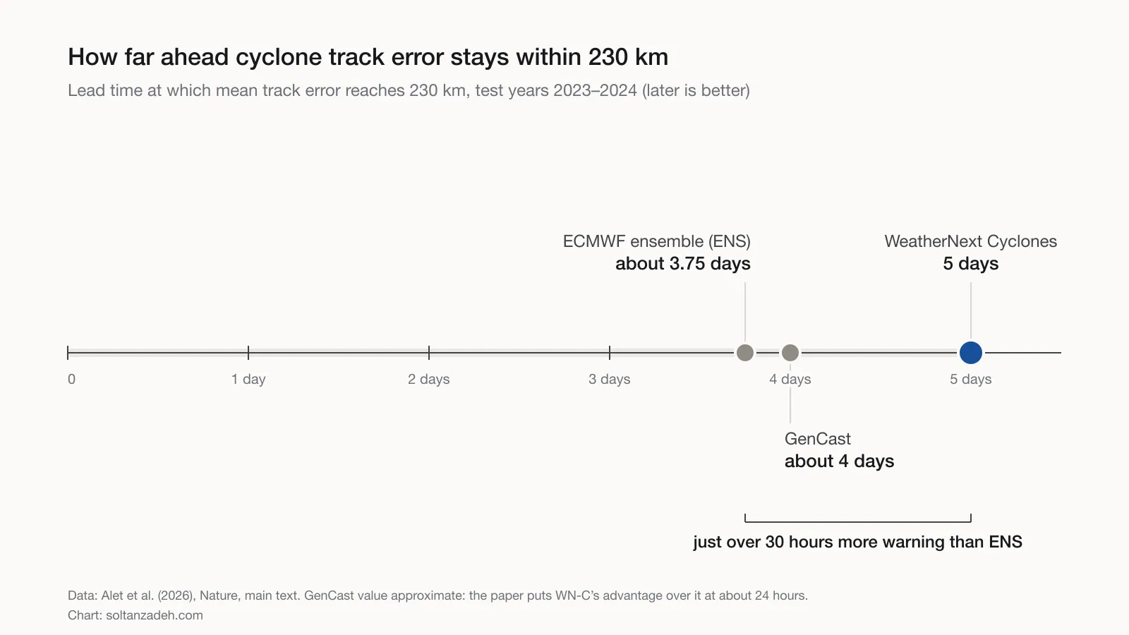
Lead time at which mean track error reaches 230 km, test years 2023–2024. The GenCast value is approximate: the paper gives WN-C’s advantage over it as about 24 hours. Values from Alet et al. (2026); chart drawn for this post.
From paper to operations
WN-C has run live since June 2025, with forecasts released publicly and to the NHC. The authors add that forecasters at other World Meteorological Organization tropical cyclone centres have also adopted its forecasts. In a retrospective simulation that blended WN-C, with weights tuned on 2022 data, into the NHC’s track and intensity consensus forecasts, adding WN-C improved track forecasts by 28 % and intensity forecasts by 6 % on average. The authors attribute this to its skill and to its errors correlating with those of physics-based models about as much as, and often less than, those models correlate with each other. On its own, WN-C beat the NHC’s track consensus and, at early lead times, its intensity consensus, but was less accurate than the intensity consensus at long lead times; the authors note that physics-based models still add substantial value for intensity.
The authors’ caveats
- Like all models that start from an analysis (here ECMWF’s operational analysis), WN-C’s forecasts arrive about 6.5 hours after the synoptic time; the paired evaluations account for this delay.
- The wind radii in IBTrACS are approximate.
- Predicting cyclone-induced rainfall, storm surge and precise wind gusts is left for future work.
- Intensity ensembles are slightly under-spread, though much better calibrated than those of ENS and GenCast.
- Moving to end-to-end systems that use raw observations directly is left for future work.
My view
Read alongside Pangu-Weather (2023) and GenCast (2024), which I summarised earlier, this paper marks a further step in a progression I find clear: from beating benchmarks, to forecasting uncertainty, to guidance used on a real forecast desk. For energy, two of its findings stand out to me: very large ensembles for rare, high-impact events, and the gain from co-training with a small, expert-curated dataset. The authors themselves describe the approach as a blueprint for other high-impact phenomena.
References
- Alet, F., Andersson, T. R., Price, I., Markou, S., El-Kadi, A., Masters, D. et al. (2026). Operational tropical cyclone forecasting with AI. Nature, published online 6 August 2026; version of record 9 September 2026. doi:10.1038/s41586-026-10953-2. Open access under CC BY 4.0.
- Code and weights: github.com/google-deepmind/weathernext, as listed in the paper’s code availability statement.
- Price, I., Sanchez-Gonzalez, A., Alet, F. et al. (2024). Probabilistic weather forecasting with machine learning. Nature, 637, 84–90. doi:10.1038/s41586-024-08252-9.
- Bi, K. et al. (2023). Accurate medium-range global weather forecasting with 3D neural networks. Nature, 619, 533–538. doi:10.1038/s41586-023-06185-3.
Charts are drawn for this post from numbers stated in, or derived from, the paper’s text (the GenCast lead time is approximate); they are not reproductions of the paper’s figures.
The views in this article are my own and do not represent those of my employer or of any organisation I am associated with.
New articles by email
A short brief whenever I publish.
The key points of each new article and a link to read it in full, about once a month. No tracking; unsubscribe at any time.
You’ll get a confirmation link first. See the privacy notice.
